
Management issues: Integrated Management and Coordination of Action
Introduction
 The Kaipara Harbour has a complex environmental management framework. The Kaipara Harbour, catchment and ecosystems are governed by mulitiple agencies: Auckland Council, Northland Regional Council, Kaipara District Council, Whangarei District Council, Northland Department of Conservation, Auckland Department of Conservation, and the Ministry of Fisheries and Foresty (MAFF). There is a plethora of plans, conflicting management philosophies and a highly fragmented legislative framework.
The land and coastal environment is currently planned and managed through:
Figure 1 depicts the current Resource Management Act (RMA) planning where there is fragmentation between land and sea planning. It is split between planning for catchments/regional plans and planning for marine areas (through coastal plans), and if a catchment has two or more districts and regions there is also split with limited overlap. Figure 2 depicts a possible pathway of integration for the Kaipara where planning occurs from the land to the sea. Recent publications by Peart 2007 and Kirschberg 2007 outlined strategies to achieve integrated management of the Kaipara. Kirschberg 2007 reviewed policy and planning documents and whether they enabled integrated management, and Peart 2007 interviewed 60 people involved in coastal management on their perspectives of current environmental planning and issues.
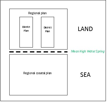
Figure 1. Fragmentation of RMA planning system
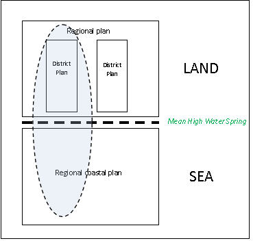
Figure 2. Integrating RMA planning
The catchment is governed and managed by other statutory documents, but mostly the RMA through the preparation of district plans focusing on landuse and regional plans focusing on broader catchment management issues such as sedimentation. However, there are many challenges for the governing bodies relating to the RMA itself including the lack of a strategic focus to planning under the Act. Therefore, we have a situation where there are different rules on the land verus the coast/marine environment and then again in the north verus the south. There is a lack of planning integration across Mean High Water Spring (MHWS) which is a widely recognised problem across the country.
Also, there is the issue of lack of planning capacity and varying resources across agencies (Table 1). Smaller councils struggle to develop and retain sufficient planning expertise to undertake their strategic planning functions and institutional memory can be lost as long–serving staff leave. This issue, together with a lack of robust information, reduces the ability to make informed decisions about development and resource use.
Table 1: Territorial Authority statistics and approach to coastal planning (source: www.localcouncils.govt.nz and Peart (2007). (1 year ended 30 June 2005)
|
Territorial Authority
|
Operating Expenditure1
|
Number of Staff
|
Land Area
(km2)
|
Separate Delineation for Coast
|
Effect of Delineation
|
Rural Subdivision rules
|
|
Rodney District Council
|
$94.1 million
|
374
|
2,427
|
No
|
Nil
|
Environmental enhancement 1 lot for 2Ha protected; 2 lots for 12Ha protected (restricted discretionary); otherwise non–complying
|
|
Kaipara District Council
|
$26.5 million
|
43
|
3,117
|
Kaipara Harbour Environment Area
|
Additional control on earthworks and vegetation clearance (but not buildings)
|
4ha minimum lot size (controlled); conservation lots 1 lot for 4000m2 min protected lot size with 4ha average in subdivision & no more than 6 in subdivision
|
Opportunities for Integration
- Developing a clear and common philosophy of how Kaipara ecosystems will be managed by tangata whenua and agencies.
- Ensure adequate provision for public participation across all sectors (i.e. fisheries, marine protection, resource consents).
- Ensure accessible and timely conflict resolution processes across all sectors.
- Improve communication between agencies so actions by one management agency do not have unintended consequences in another agency.
- Integrate planning at compatible scales
- Build trust to achieve effective integrated management
References:
- Peart, R. 2007. Beyond The Tide. Integrating the management of New Zealand’s coasts. Environmental Defence Society. 212pp.
- Kirschberg, A. 2007. Kaipara Harbour Coastal Environment Policy Review. Auckland Regional Council Technical Publication Number 345. 68pp.
Related publications