Management issues: Resource use & development
Introduction
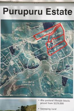
Farming, exotic forestry and urban/lifestyle blocks dominate a large majority of landuse in the Kaipara Harbour catchment. There is no comprehensive documentation of landuse change within the Kaipara harbour catchment. However, one of the most obvious more pervasive landuse changes is the increase of urban areas, especially along the coastal margin of the Kaipara Harbour. Interest in residential subdivision on the harbour has increased, as property prices on the east coast escalate dramatically. This is especially in areas of the harbour accessible to major highways and Auckland such as, South Head, Pahi and along Oneriri Road on the Puketotara Peninsula overlooking the Otamatea River.
The Kaipara is seeing a change of larger more productive farms amalgamating and then smaller farms selling to subdivision for lifestyle development (i.e. blocks of land around 3ha with rural outlook) or coastal settlement to urbanise the small township, such as Tinopai, Whakapirau, Baylys Beach, and Pahi – all of which are on septic sewerage systems.
With exception of Helensville, Kumeu–Huapai and Waimauku townships, most of the Rodney District area of the Kaipara Harbour catchment is zoned rural. The Kaipara District is entirely zoned rural except for an overlay zone along the coastal edge of the Kaipara Harbour (i.e. Kaipara Harbour Environment Area).
The Auckland Regional Council (ARC) Growth Strategy, which includes the Rodney District, has indicated that population growth in the region is expected to be high with townships such as Kumeu–huapai and Helensville expected to double in size. The Rodney District Council (RDC) Structure Plan indicates that Kumeu–Huapai–Waimauku area is expected to grow by 3 to 5% annually with the Kumeu–Huapai area expected to settle some 25,000 to 30,000 people.
In the northern Kaipara, the KDC is currently reviewing its strategy and district plan in the context of developing its LTCCP. The KDC are planning to be guided by a growth strategy, but due to a lack of resources to carry out any detailed studies of the district, the plan is likely to place the onus on developers to undertake rigorous assessment of effects of development in rural areas.
Urbanisation
Urbanisation leads to an increase in the area of solid surfaces in a catchment such as roads, roofs, carparks, and drainage systems. The increasing number of drains rapidly transport rainwater run–off into waterways and decreases the amount of rainwater flowing back into the groundwater. Consequently, surface water is quickly transported to nearby waterways. This rapid transportation of rainwater reduces groundwater retention and lowers the baseflow conditions for urbanised streams and increases floods.
The increased proportion of solid, impermeable surfaces in a catchment has been proposed as a general indicator of modifications to urban waterways. With the increase in solid surfaces is a reduction of riparian vegetation. This increases the impacts of the rainwater run–off due to a reduction in the buffer zone between the land and stream environment (i.e., riparian zone). A reduction in a riparian zone also increases a streams direct exposure to sunlight, thereby increasing water temperatures and aquatic plant. Greater stream temperatures can be detrimental to aquatic life, which is a common feature of the urban stream environment.
Urbanisation may also introduce contaminants and sediment created from urban and industrial activities. The contaminants (e.g., copper, lead, zinc), can be deposited onto roads, roofs and other hard surfaces before being collected by rainwater run–off in transit to nearby streams.
Very little specific information on the effects of urbanisation on waterways in the Kaipara catchment is available. Studies in the Waitakere and North Shore Cities have shown the effects of urbanisation on the ecology of streams related to catchment modification.
Sandmining
There are two coastal permits allowing for the sandmining of 400,000m3 per year, for five years, from the Kaipara Harbour entrance, flood tidal delta. The permits were granted to Mt Rex Shipping Ltd and Winstone Aggregates in July 2006. Current extraction rates are approximately 219,000m3 per year for the Kaipara sector. Sand from the Kaipara Harbour entrance currently contributes over 50% of the concrete sand requirements for Auckland.
Nga Kaitiaki and the local community of the Kaipara believe this activity is having a severe impact on the mauri (lifeforce) of the Kaipara. The location of the sandmining at Taporapora holds tremendous significance to Ngati Whatua. Taporapora, much of it is now underwater or eroded, was the landing site of the mahuhu waka of ngati whatua and carried Rongomai the Chief. Here the ancestors of Ngati Whatua installed their sacred relics from Hawaiiki in a newly built meeting house and named the settlement Taporapora after a remembered place in the homeland.
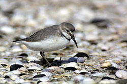
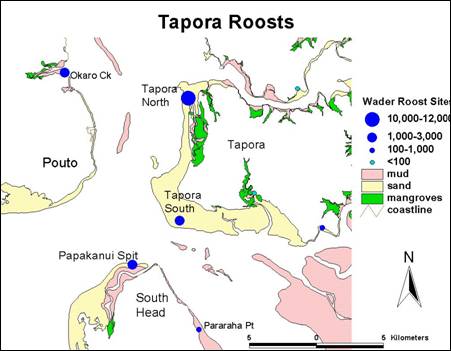
Taporapora is also a significant breeding, feeding and roosting area for tens of thousands of NZ and migratory birds. The Kaipara Harbour is unofficially considered internationally significant in terms of its ornithological value. Coastal vegetation and landforms within the Kaipara are also recognised as being of regional significance by Department of Conservation and the Auckland Regional Council in their respective planning documents (e.g. ARC Policy Statement and the DoC conservation management strategy).
Aquaculture
Aquaculture occurs in several areas of the Kaipara harbour, but mainly in the northern Kaipara where oysters are farmed. More recently plans for large marine farms in the southern Kaipara have been proposed due to its high water quality.
Planning for aquaculture in the Kaipara harbour has become an important issue because of the change in aquaculture laws and planning changes by regional councils. All aquaculture must now occur in declared Aquaculture Management Areas (AMAs) which have yet to be identified for the Kaipara Harbour.
Resource consent has been granted by the Environment Court to Biomarine Ltd for a oyster farm adjacent to Orongo Point, Taporapora peninsula. The main issue has been the impact of the oyster farm on the subtidal seagrass (Zostera) which is ecologically important habitat and quite rare throughout New Zealand and is locally significant for the entire Auckland region.
But there is currently no underlying AMA for the site, but it is believed that this marine farm application has escaped the moratorium put in place during the aquaculture reforms. Both NRC and ARC are shifting towards utilizing a private plan change procedure rather than council initiated planning process to identify suitable areas for aquaculture marks a move back to ad hoc approach to planning for aquaculture. This is because each private plan change application is considered separately, rather than as part of a broader strategic integrated planning approach.
References:
- KML. 2004. Overview Aquatic Ecological Issues and Proposed Aquatic Ecological Zones in the Kaipara River Catchment Title. Prepared by Kingett Mitchell Ltd. For Rodney District Council. 36pp.
- Peart, R. 2007. Beyond the Tide. Integrating the Management of New Zealand’s Coasts. Published by Environmental Defence Society, New Zealand. Auckland. 210pp.
- ARC. 1999. Auckland Regional Growth Strategy. 2050. Published by Auckland Regional Council, Auckland. 89pp.
- RDC. 1998. RDC Structure Plan.
- Environs Holdings Ltd. 2007. Te Uri o Hau Effects Assessment Report. Of a Proposal by Crest Energy Ltd to Construct and Operate a Tidal Powerstation in the Kaipara Harbour. August 2007. 65pp.
Related publications
| Year |
Author |
Title |
Type |
Size |
| 2011 |
Taylor R, Mullooly, G |
Wananga Workshop Presentation: Hanerau Farms Ltd. Te Uri o Hau Tangata Whenua. IKHMG Presentation, April 2011
|
 |
1.8 MB |
| 2010 |
IKHMG |
Information Review & Gap Analysis. The Kaipara Atlas: An Integrated Database.
|
|
15.5 MB |
| 2010 |
Department of Conservation |
New Zealand Coastal Policy Statement 2010, December 2010
|
|
509 KB |
| 2010 |
IKHMG |
The World of Kaipara. Information Review & Gap Analysis. Chapter 1 to 8. Purpose, Introduction, Historical Background and Methodology.
|
|
1.6 MB |
| 2010 |
IKHMG |
The World of Kaipara. Information Review & Gap Analysis. Chapter 10. Restoring Sustainable Use of Fish & Invertebrate Stocks.
|
|
3.1 MB |
| 2010 |
IKHMG |
The World of Kaipara. Information Review & Gap Analysis. Chapter 11. Restoring the Mauri of Kaipara.
|
|
2 MB |
| 2010 |
IKHMG |
The World of Kaipara. Information Review & Gap Analysis. Chapter 14. Integrated and Co–operative management of Kaipara ecosystems, harbour and catchment.
|
|
2 MB |
| 2010 |
IKHMG |
The World of Kaipara. Information Review & Gap Analysis. Chapter 15. Discussion.
|
|
276 KB |
| 2010 |
IKHMG |
The World of Kaipara. Information Review & Gap Analysis. Chapter 16. Appendix.
|
|
2.1 MB |
| 2010 |
IKHMG |
The World of Kaipara. Information Review & Gap Analysis. Chapter 9. Protecting & Restoring Native Biodiversity.
|
|
9.7 MB |
| 2010 |
IKHMG |
The World of Kaipara. Information Review & Gap Analysis. Executive Summary.
|
|
1.6 MB |
| 2009 |
Morrison M, Lowe M, Parsons D, Usmar N, McLeod I |
A review of land-based effects on coastal fisheries and supporting biodiversity in New Zealand. New Zealand Aquatic Environment and Biodiversity Report No. 37, 2009. 102 pp.
|
|
5.5 MB |
| 2009 |
Kench, P., Hosking, P., and D Jenkinson |
Kaipara Harbour Coastal Monitoring Program. 2008 Annual Report. Auckland Uniservices Ltd. 48p.
|
|
5.7 MB |
| 2008 |
Ministry for Environment |
Coastal Hazards and Climate Change. A Guidance Manual for Local Government in New Zealand. 2nd Edition. 139 p.
|
|
4.8 MB |
| 2008 |
Reeve, G, Swales, A and J Reed |
Kaipara Harbour Sediments: Information Review. Prepared by NIWA For Auckland Regional Council and Northland Regional Council. TP 2009/055
|
|
2.6 MB |
| 2008 |
Bellingham, M., and A., Davis. |
Stock Grazing Impacts on Estuarine Vegetation in the Southern Kaipara Harbour
|
|
5.6 MB |
| 2007 |
Ministry for the Environment |
Environment New Zealand 2007 |
 |
|
| 2007 |
Campbell P |
Kauri Cameraman Tudor Washington Collins 1898 1970 Limited Edition |
|
|
| 2004 |
Froude, V.A., Smith, R. |
Area-based restrictions in the New Zealand marine environment. |
|
|
| 2004 |
Marjorie van Room
Stephen Knight |
Ecological Context of Development
New Zealand Perspectives |
|
|
| 2004 |
Grave, R V |
Kaipara Harbour Sand Extraction. Fitzgerald Bank Biological Monitoring. Report prepared for Winstone Aggregates Ltd & Mt Rex Shipping Ltd.
|
|
2.3 MB |
| 2004 |
Hume, T., Green, M., Nichol, S., and Parnell, K. |
Kaipara sand study final report: sand movement, storage and extraction in the Kaipara tidal inlet. Prepared for Kaipara Sand Study Working Party. NIWA Client Report HAM2002-064. 61p.
|
|
872 KB |
| 2003 |
Ferreira, S M., and C C Roberts |
Distribution and abundance of Maui dolphin (Cephalorhynchus hectori maui) along the North Island west coast, New Zealand. DOC Science Internal Series 93. 18p.
|
|
222 KB |
| 2003 |
Ministry of Fisheries |
Strategic Plan 2003-2008 |
|
|
| 1975 |
Schofield, J.C. |
Sea-level fluctuations cause periodic, post-glacial progradation, south Kaipara barrier, North Island, New Zealand. NZ J Geology and Geophysics. 18(2):295-316
|
|
1.1 MB |
| |
