Management issues: Sedimentation and water quality
Introduction
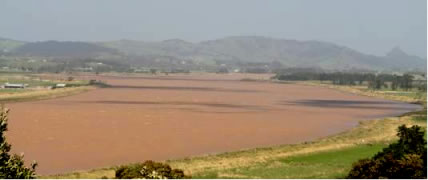
The widespread siltation of the Kaipara harbour is a significant problem. No comprehensive research has been carried out on sedimentation rates for any part of the Kaipara. However, the impacts of sedimentation are found to cause a decline in biodiversity, ecological integrity, and generally degradation of the estuarine and marine environment.
The major sources of sediment runoff entering the harbour are through land practices, such as removal of vegetation and forests, grazing and earthworks. Like many other catchments in New Zealand, significant land clearing and other modifications to the land has occurred. In 1984, it was estimated that 43% of wildlife habitat in Northland had either been reduced in area or totally lost between 1978 and 1983. The ARC commissioned research in 1994 to review the contribution of sediment from various landuse. The research indicated that earthworks had the potential to produce over 100–fold more than other types of landuse, such as pasture and residential areas.
|
Landuse
|
Predicted average annual soil loss (over 20years)
(tonnes/km2/yr)
|
|
Earthworks
|
16,800
|
|
Developed Urban – industrial use
|
100
|
|
Developed Urban – residential use
|
24
|
|
Pasture
|
46
|
|
Market gardening
|
52
|
|
|
There is no doubt that the removal of scrublands (e.g. manuka, kanuka and fern bush) and forest (e.g. kauri and broadleaf–podocarp forests) has had severe consequences for the Kaipara estuarine environment. Soil erosion has accelerated, directly leading to sedimentation of the harbour and potentially altered the community structure of marine habitats.
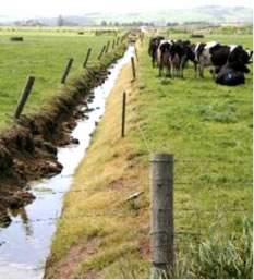
Sediment runoff from the land carries with it nutrients, mostly nitrogen and phosphorous. Animal faeces and urine wash off paddocks and enter waterways directly when farm animals are typically given free access to streams, lakes, wetlands, and estuaries. The daily washing out of dairy shed wastes generates large quantities of sewage that needs to be treated on site. It has been found that 75% of total nitrogen in waterways is likely to come from farming land.
|
| Drains and diary cows, Ruawai Flats |
|
Wairoa River, Dargaville
The Kaipara Harbour and its rivers have long been famous for mud. Even before Pakeha began the large–scale removal of the forests in the catchment, the Wairoa River had a “yellow appearance” due to the clay and fertile soil it carried. However, it’s been the anecdotal evidence of locals and historical information that describes the change in water quality of the Kaipara harbour foreshore habitats and waterways.
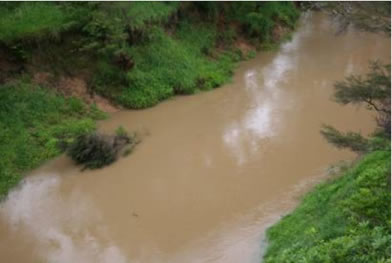
Upper Hoteo River
Poor water quality as a result of high levels of sediment and nutrients has found to cause the die–off of shellfish beds in the Kaipara harbour. High levels of suspended solids can smother marine organisms living on the seafloor where many are filter feeders relying on good water clarity and phytoplankton to grow. High levels of suspended solids also reduces the amount of sunlight reaching organisms that need to photosynthesize and grow.
Up until 1953, with the introduction of the Water Pollution Act, there was no comprehensive control over water quality and pollution in NZ. However, water quality was not given adequate attention until the 1970’s. Although poor farming practices such as overgrazing and allowing stock access to river and coastal margins can result in significant sedimentation, only Environment Waikato currently regulates grazing and stock access to water bodies (Table 1). Both the Auckland and Northland Regional Councils rely on voluntary measures to reduce impacts of farming on waterways, riparian vegetation, coastal habitat and biodiversity.
Table 1. Government Agency control for sedimentation generated from grazing and stock access to waterways.
|
Regional Council
|
Type of
Regulation
|
Voluntary Measures
|
|
Northland Regional Council
|
Permitted Activity
(provided environmental standards are met)
|
Yes. Focus on using financial incentives
|
|
Auckland Regional Council
|
No rules
|
None
|
|
Ministry of Fisheries
|
None
|
None
|
|
Department of Conservation
|
None
|
Advisory role only
|
Water is very important to the hapu of the Kaipara. Water is a living entity, a taonga of Papatuanuku. It is vital for sustaining life and all water (freshwater and saltwater) begins as a scared gift. Every waterway or body of water has its own source of life, mauri. It is believed that mixing of water or separation or division of natural systems can markedly affect the mauri of many places. Maori focus on keeping all parts of the natural environment pure, unpolluted and connected.
Kaimoana is and has always been an important food source and hence the significance of marae being situated in close proximity to the sea – the foreshore was part of every community’s “garden”.
An integrated catchment–level focus is required here to address the impacts of sedimentation and declining water quality. Research is urgently required to look at the carrying capacity of the downstream environment and cumulative impacts of resource use. Ongoing improvement in landuse management practices at a property and landscape level is dependent on landowners and management agencies understanding their duty of care to the land and the environment and the impact of their activities. There is a need to improve the way sediment, nutrient and pesticide runoff is controlled and how wetlands, coastal and riparian habitats are protected and restored in the catchment.
Mangroves
Mangrove forest expansion has recently become an issue for management agencies. Our current state of knowledge suggests that increased rates of sedimentation in estuaries and harbours have resulted in spread of mangroves. This is due to increases in the elevation of intertidal areas and establishment of suitable habitat for mangroves. The rate of spread of mangroves is dependent not only on sedimentation rates but also other environmental conditions such as the influence of wind and waves on moving sediment. Elevated nutrient loadings, particularly nitrogen, through enhanced growth rates, are also thought to be a determining factor in the acceleration of mangrove spread in some NZ estuaries.
Mangrove forest expansion seems to have been most active since the late 1970s and have rapidly (over a decade or so) expanded seaward in the Kaipara. This may also be due to the prohibition of mangrove removal to create farmland or urban/industrial development in the 1970s. Today removal of mangroves is a lot more controlled.
Scientific research of New Zealand’s mangroves and fish assemblages has found that mangroves are important juvenile fish nursery for grey mullet (especially mangroves of the Kaipara and Manukau), short–finned eel and parore.
References:
- KML. 2004. Overview Aquatic Ecological Issues and Proposed Aquatic Ecological Zones in the Kaipara River Catchment Title. Prepared by Kingett Mitchell Ltd. For Rodney District Council. 36pp.
- Morrisey, D., Beard, C., Morrison, M., Craggs, R., and Lowe, M. (2007). The New Zealand Mangrove: a review of the current state of knowledge. Auckland Regional Council Technical Publication TP325. 162p.
Related publications
| Year |
Author |
Title |
Type |
Size |
| 2011 |
Taylor R, Mullooly, G |
Wananga Workshop Presentation: Hanerau Farms Ltd. Te Uri o Hau Tangata Whenua. IKHMG Presentation, April 2011
|
 |
1.8 MB |
| 2011 |
Morrison, M |
Wananga Workshop Presentation: NIWA fish–habitat focused research programs: efforts in the Kaipara Harbour
|
|
6.8 MB |
| 2010 |
IKHMG |
Information Review & Gap Analysis. The Kaipara Atlas: An Integrated Database.
|
|
15.5 MB |
| 2010 |
IKHMG |
The World of Kaipara. Information Review & Gap Analysis. Chapter 1 to 8. Purpose, Introduction, Historical Background and Methodology.
|
|
1.6 MB |
| 2010 |
IKHMG |
The World of Kaipara. Information Review & Gap Analysis. Chapter 10. Restoring Sustainable Use of Fish & Invertebrate Stocks.
|
|
3.1 MB |
| 2010 |
IKHMG |
The World of Kaipara. Information Review & Gap Analysis. Chapter 14. Integrated and Co–operative management of Kaipara ecosystems, harbour and catchment.
|
|
2 MB |
| 2010 |
IKHMG |
The World of Kaipara. Information Review & Gap Analysis. Chapter 9. Protecting & Restoring Native Biodiversity.
|
|
9.7 MB |
| 2010 |
IKHMG |
The World of Kaipara. Information Review & Gap Analysis. Executive Summary.
|
|
1.6 MB |
| 2009 |
Morrison M, Lowe M, Parsons D, Usmar N, McLeod I |
A review of land-based effects on coastal fisheries and supporting biodiversity in New Zealand. New Zealand Aquatic Environment and Biodiversity Report No. 37, 2009. 102 pp.
|
|
5.5 MB |
| 2009 |
Auckland Regional Council |
ARC Environmental Management committee, Update on Monitoring & Research Activities in the Kaipara Harbour
|
|
3.2 MB |
| 2009 |
Kelly, S |
Kaipara Harbour Oyster Reserves. Final Research Report OYS2008/02, March 2009. 32p.
|
|
1 MB |
| 2008 |
Haggit T, Mead S, and M Bellingham |
Kaipara Harbour Environmental Information Review. ARC Technical Publication TP 354.
|
|
7.2 MB |
| 2008 |
Reeve, G, Swales, A and J Reed |
Kaipara Harbour Sediments: Information Review. Prepared by NIWA For Auckland Regional Council and Northland Regional Council. TP 2009/055
|
|
2.6 MB |
| 2007 |
Ministry for the Environment |
Environment New Zealand 2007 |
 |
|
| 2007 |
Scarsbrook, M. |
River water quality. State and trends in the Auckland Region. Auckland Regional Council Technical Publication No. 336, 2007. 48pp.
|
|
1 MB |
| 2007 |
Donald Morrisey, Catherine Beard, Mark Morrison, Rupert Craggs, Meredith Lowe |
The New Zealand Mangrove: Review of the Current State of Knolwedge.
|
|
1.2 MB |
| 2005 |
Morrison, M. |
An information review of the natural marine features and ecology of Northland. Prepared for Department of Conservation.
|
|
12.2 MB |
| 2005 |
Hewitt, J.E., and Funnell, G.A. |
Benthic marine habitats and communities of the southern Kaipara.
|
|
2.9 MB |
| 2004 |
Marjorie van Room
Stephen Knight |
Ecological Context of Development
New Zealand Perspectives |
|
|
| 2004 |
Hume, T., Green, M., Nichol, S., and Parnell, K. |
Kaipara sand study final report: sand movement, storage and extraction in the Kaipara tidal inlet. Prepared for Kaipara Sand Study Working Party. NIWA Client Report HAM2002-064. 61p.
|
|
872 KB |
| 2002 |
Davis, A. |
Kaipara Ecological District: Ecological character, threats and management needs. Final Report.Draft Two. June 2002. 184p.
|
|
4.8 MB |
| 2002 |
Davis, A. |
Otamatea Ecological District: Ecological character, threats and management needs. Final Report. Draft Two. June 2002. Aristos Consultants. 125pp.
|
|
2.5 MB |
| 1999 |
Hayward B, Grenfell H, Scott D |
Tidal range of marsh foraminifera for determining former sea–level heights in New Zealand
|
|
3.3 MB |
| |
